Physical Characteristics of The Province |
|
|
 Geographical Background Geographical Background
Political Subdivision
Land Area
Topography
Soil Type
Hydro Resources
Meteorology and Climate
Mineral Deposits
|

|
 Geographical Background Geographical Background
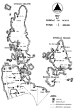
Surigao del Norte is strategically located at the Northeastern part of
Mindanao between 125o 15' to 126o 15' east longitude and 9o 18' to 10o
30' north latitude. It is bounded on the North and East by the Pacific Ocean,
on the South by the Provinces of Agusan del Norte and Surigao del Sur and
on the West by the Surigao Strait. It is one of the four (4) provinces under
the Caraga Region (Region XIII). [TOP]
|
|
Political Subdivision
The province is made up of twenty seven (27) municipalities, one (1) city and
four hundred thirty four (434) barangays. It is divided into two Congressional
Districts. District I comprises the islands of Dinagat, Siargao and Bucas
Grande with sixteen (16) municipalities namely: Basilisa, Burgos, Cagdianao,
Dapa, Del Carmen, Dinagat, General Luna, Libjo, Loreto, Pilar, San Benito,
San Isidro, Santa Monica, San Jose, Socorro and Tubajon. District II
includes eleven municipalities and one city namely: Alegria, Bacuag, Claver,
Gigaquit, Mainit, Malimono, Placer, San Francisco, Sison, Tagana-an, and
Tubod with Surigao City as its provincial capital. [TOP]
|
|
Land Area
The province of Surigao del Norte embracing the mainland (including Surigao
City) and the two large islands has a total land area of 288,905 hectares. The
mainland area occupies 129,850 hectares or 47.41%; Siargao island
possesses 62,577 hectares or 22.85% and Dinagat island covers 81,475
hectares or 29.74 % of the total land area. The land area of the province is
roughly equivalent to 14.00% of the total land area of Region X111
(19,555.18 Sq. Km.), 2.69% of the total land area of Mindanao (101,999
Sq. Km.) and represents 0.94 % of the total land area of the Philippines
(300,000 Sq. Km). [TOP]
|
|
Topography
The mainland portion of the province has a varied terrain ranging from flat,
rugged to mountainous. A mountain range located along the boundary of the
municipalities of Tubod, Bacuag and Mainit is Mt. Diwata with an elevation
of 750 meters. On the north eastern part of Sison-Placer-Mainit boundary is
Mt. Buhangin with an elevation of 664 meters and flanking the western side
along the boundary of Mainit-San Francisco is Mt. Tendido with an elevation
of 865 meters. Two common mountain range namely: Mt. Satellite having an
elevation of 1,016 meters and Mt. Agudo with 1,018 meters above sea level
are found in Malimono.
Adjoining the municipality of Alegria and the municipality of Kitcharao in
Agusan del Norte is Mt. Kabutan with an elevation of 975 meters. At the
southeastern part bordering Surigao del Sur and Municipality of Claver lies
Mt. Legaspi with an elevation of 1,170 meters above sea level. The
mountainous eastern side of Dinagat Island is dominated by Mt. Redondo
and Mt. Kanbinliw in Loreto with elevations reaching over 900 meters.
Dinagat Island was proclaimed as mineral reservation under Proclamation
No. 391 in March 13, 1939. However, in November 9, 1993 around 5,072
hectares were segregated from the reservation as production areas pursuant
to Proclamation No. 295.
The terrain in Siargao Island is predominantly rolling to steep. The highest
elevation is 291 meters above sea level located along the middle Bucas
Island. On the western and southern sides of the island are broad expanse of
mangrove swamps and broad reef flats. The island is proximate to the
Philippine deep which is 10,700 meters below sea level and considered as
the deepest part of the trench . [TOP]
|
|
Soil Type
The soils in the province is basically clay and sandy loam types. The soils in
the mainland area is generally classified as loam soil characterized as
permeable, moderately drained and highly suitable for agricultural
development. The Dinagat island soils, is dominated by Dinagat clay loam
which comprised 70%, 20% of Cabatohan loam, and 10% of Bolinao clay
steep phase. It is characterized as friable, slightly sticky and granular in
nature.The soil type in Siargao island is : 80% Bolinao clay, 60% Cabatohan
clay and 10% Jamoyaon clay loam. The island of Bucas Grande is highly
acidic due to the presence of mineral ores thereby needing careful soil
management. [TOP]
|
|
Hydro Resources
The province has a major lake and six (6) rivers. Lake Mainit which is
located within the administrative boundaries of the provinces of Agusan del
Norte and Surigao del Norte has a total lake area of about 17,000 hectares.
It is potential for Hydro or geothermal power. On the other hand, Baoy
River which crosses the municipalities of Claver and Gigaquit is being tapped
to supply irrigation water to some 1,000 hectares of ricelands. Other notable
rivers supplying water for irrigation and domestic purposes are the
Magpayang and Mayag rivers in the municipalities of Mainit and Tubod. All
are tributaries to Lake Mainit. Payapag river which connects to Campo river
drains to Bacuag Bay. The Anao-oan river and Surigao river are sources of
quality sand and gravel for the municipality of Anao-aon and Surigao City.
[TOP]
|
|
Meteorology and Climate
Surigao del Norte is less frequented by typhoons as shown in the climate
map of the Philippines of PAG-ASA, Weather Bureau. But the province is
often used as a reference point for tropical disturbances entering the country.
It has a type II climate characterized by no pronounced dry season with a
very pronounced maximum rain period from November to January. It
receives an average annual rainfall of 288.13 mm. The average monthly
maxima is 600 mm on December and January, and monthly minima of about
150 mm in August and September. The average number of rainy days per
month is 20 to 25 from November to March and 13 to 18 from April to
October. Temperature ranges from a low of 23.5oC in October and
February to a high of 32.0oC in March and September. Average annual
relative humidity is 82.91 percent and the average annual wind velocity is
3.10 meters per second. [TOP]
|
|
Mineral Deposits
The province is blessed with ample mineral deposits which are potential for
mining development. These include large tonnage of nickel-cobalt bearing
ferruginous laterite, chromite deposits with occurrences of lumpy and sandy
ores of metallurgical and chemical grade (50,000 to 500,000 tons), gold
deposits with appreciable amount of silver as by product, primary manganese
deposits in siliceous zones, occurrences of black sand mainly magnetite,
ferruginous laterites with more than 40% Fe and Ferruginous bauxite (Al2
O3) deposits, silica sand deposits, occurrences of carbonaceous shales and
coal, guano deposits confined to limestone caves, clays for bricks and tiles,
sand and gravel of igneous rocks deposits. [TOP]
|
|